


Land sales from the public domain were recorded by field employees of the
U.S. General Land Office, state and local officials, and clerks of the
Illinois Central Railroad. These records were transferred to the Illinois
State Archives for permanent retention in 1957. Because the records are
arranged by legal description, a database was developed to allow the records
to be searched by name.
The database contains information about nearly 550,000 land sales from the
54,740 square miles of the public domain sold within Illinois. Each purchase
entry includes the purchaser's name, purchase date, number of acres, price
per acre, numeric code indicating the county in which the land is located,
legal description (township, section, range), volume and page numbers of
original entry, and variously, the sale type, and the purchaser's sex and
residence.
Extracted from Illinois State Archives: Illinois Public Domain Land Tract Sales
Original Land Owners Map lets you navigate through the county to see a list of the owners of each section.
| Fayette | Effingham | Jasper |
| Marion |
 |
Richland |
| Wayne |
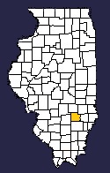


Clay County ILGenWeb Copyright
Design by
